Remote Roof Scanning

Address-Based Roof Measurements

A digital roof model created through satellite imagery in seconds, complete with measurement and reporting tools.

Trusted by

How It Works

Four Easy Steps

Step 1

Enter Address

Type the building’s address directly in the search bar.

Step 2

Locate Roof

Select and zoom in on the correct building from the satellite view.

Step 3

Capture Data

Scan the roof’s layout and dimensions with automated geospatial analysis.

Step 4

Get Measurements

Receive accurate measurements and area details within seconds.

Benefits

Why Choose This Tool

Speed

Speed

Measurements and quotes delivered in seconds.

Lower Costs

Lower Costs

No need for site visits or extra resources.

Safety

Safety

No need for ladders or unnecessary climbing.

Effectiveness

Effectiveness

Reliable data that is immediately accessible.

Features

The Power of Precision at Your
Fingertips

Measurement Tools
Facade Tools
Visual Proof
Smart Notes
Site preparation in minutes

Measurement Tools

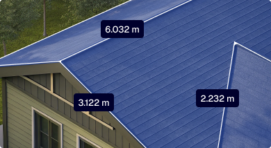
Measure surfaces, distances, slopes, heights, and more...

Facade Tools

Capture vertical surfaces and wall areas...

Visual Proof

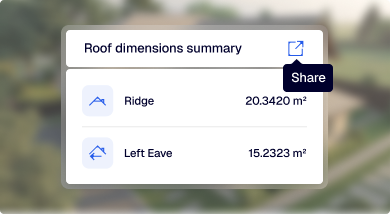
Deliver 2D/3D models with every measurement...

Smart Notes

Add labels, markups, and comments...

Site preparation in minutes

Define crane setup, lifting height and reach...

testimonials

What Our Customers Say

Start Your Free Trial

Get hands-on with AiroCollect — no credit card, no commitment. Start scanning, measuring, and quoting faster today.

1 Month Access

Try AiroCollect free for a full month with access to all features and tools. Includes dedicated support to help you get started fast.

4 Scans Included

Process up to four scans. Generate 2D, 3D, and mesh outputs with just a few clicks.

Works in Your Browser

No downloads or setup required. Access the platform directly from any browser on any device.

Measure & Simulate

Calculate distance, surface, height, and much more. Run solar simulations and export full project reports.

FaQ

Have Questions?

Do I need special equipment?

No additional equipment is required. A model is generated automatically from the property address using satellite images.

The model can be used to calculate dimensions, surfaces, and slopes, run simulations, and generate detailed reports for clients or internal use.

A complete roof model is created within seconds of entering the address.

All users get access to dedicated onboarding and ongoing support. Whether you have a technical question or need help with a scan, we’ve got your back.

Payments are processed through a secure online payment provider. Once your order is placed, everything is handled automatically.

Yes. Any plan can be paid monthly, and you can cancel at the end of any month.

Don’t See The Answer You Need?

If you don’t see the answer to your question send us a message and we will answer you as soon as possible, within a few hours.

Try AiroCollect

Enjoy 30 days of full access with included scans. No credit card required.