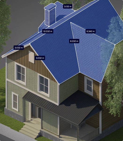
Roofing Companies
AiroCollect is your all-in-one measurement and reporting tool designed to help you quote faster and plan smarter.
Tile Surface
76.024 m²
Ridge Length
30.032 m
Ridge Height
Ridge Angle
6.8°
Total
76.024 m² / 2 slopes
Benefits
Features
Measure surfaces, distances, slopes, heights, and more...
Capture vertical surfaces and wall areas...
Deliver 2D/3D models with every measurement...
Add labels, markups, and comments...
Define crane setup, lifting height and reach...
Capture Tips
Flight Patterns
Linear Pattern
Flight Path
Fly in straight, parallel lines above the terrain — think of it like mowing a lawn.
Camera Angle
Set your drone’s camera to -90° (facing straight down).
Photo Mode
Enable timed shooting to capture a photo every 2 seconds automatically.
Number of Passes
Complete at least 3 orbits directly above the roof for full coverage.
Speed
Keep your drone speed low, no more than 2 meters per second.
Altitude
Maintain a consistent height of around 30 meters above the ground.
Flight Patterns
Linear Pattern
Altitude
After the main scan, fly a circular route around the structure at the same altitude.
Photo mode
Enable timed shooting to capture a photo automatically every 2 seconds.
Camera
Set the camera angle between 45° and 60° to keep the building centered in every frame.
Passes
Fly one full circle around the building.
Speed
Keep your drone speed low, no more than 2 meters per second.
testimonials
FaQ
Yes, you can. AiroCollect is compatible with any drone that can capture images and records GPS coordinates. If you’re using an RTK-GPS drone, AiroCollect will automatically detect it and adjust the coordinate system accordingly.
If you have a DJI MINI 1, MINI 2 (not SE), or MINI 3 drone, you can download the free AiroCollect app for Android (iOS is not supported due to DJI restrictions) from our technical specifications page. This app allows your drone to scan terrain automatically.
We recommend the DJI MINI 4 PRO. Weighing under 250g, it’s one of the easiest drones to operate and comes with fewer regulatory restrictions. However, you may need special approval to fly near airports or other restricted zones. Always consider privacy, too. If you’re flying over private property, make sure you have the owner’s permission. For full legal guidance, refer to the drone regulations provided by your local authorities.
You can either purchase the same license again, choose a different one, or simply wait for your current plan to renew.
All users get access to dedicated onboarding and ongoing support. Whether you have a technical question or need help with a scan, we’ve got your back.
With the free trial, you get 1 month of full access to all AiroCollect features — no credit card required. This includes 4 drone scans with support for 2D, 3D, and mesh outputs, using any GPS-enabled drone (like DJI Mini or Mavic). You can measure distance, surface, volume, and height, run solar panel simulations, and export detailed reports. Plus, you’ll have full support from our team to help you get started.
If you don’t see the answer to your question send us a message and we will answer you as soon as possible, within a few hours.
Get 30 days of unlimited access and 4 included scans. No commitment
Solutions
Products
Company